Lapland → Landscapes → Summer & Fall → Aerial photo above Sitojaure towards Sarek

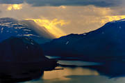
Aerial photo above Sitojaure towards Sarek


The lake Sijddojavrre leads in towards the Sami village Rinim and the centre of the high mountain region, the national parks Sarek and Stora Sjöfallet. Together with Padjelanta, the three national parks make up an area of more than 5,000 square metres, as large as half of Skåne
Picture taken 2007-07-15Camera direction 315°
From position: Latitude: 67.251862 Longitude: 18.361918
Sitojaure Kvikkjokk Lappland Sweden © Copyright: Tomas Johansson
You can purchase the image digitally for print or website use
Click on the top left corner of the image to open an email
Fill in your requests and send the email to us.
.