Lapland → Landscapes → Summer & Fall → Kungsleden aerial photo

Kungsleden aerial photo


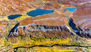
Kungsleden (The Kings Trail) is the mountain worlds most well-known trail. It runs from Abisko to Hemavan Bierke, 440 kilometres. Kungsleden was the initiative of STF at the beginning of the 20th century, and when the national trail system for the mountains was created in 1977, Kungsleden was included.
Picture taken 2010-09-08Camera direction 153°
From position: Latitude: 67.303868 Longitude: 18.475222
Avtsusjjåhkå Saltoluokta Lappland Sweden © Copyright: Tomas E Johanson
You can purchase the image digitally for print or website use
Click on the top left corner of the image to open an email
Fill in your requests and send the email to us.
.