Lapland → Landscapes → Summer & Fall → Kvikkjokk and Sarek

Kvikkjokk and Sarek


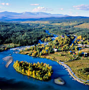
The mountain station in Kvikkjokk Huhttan is at elevation near the river, further up in the photo. It is the starting point for many hikers to the mountains, who intend on going into Sarek or Padjelanta. Silver was found further into the mountains in the mid-1700s and a mining community was built near the discharge for Gamajåhkås. But the operation was not profitable and closed in 1702. In total, 532 kilograms of silver were extracted, and 100 tonnes of lead, as a bi-product.
Picture taken 1999-09-06Camera direction 2°
From position: Latitude: 66.945992 Longitude: 17.71658
Kvikkjokk Lappland Sweden © Copyright: Tomas E Johanson
You can purchase the image digitally for print or website use
Click on the top left corner of the image to open an email
Fill in your requests and send the email to us.
.